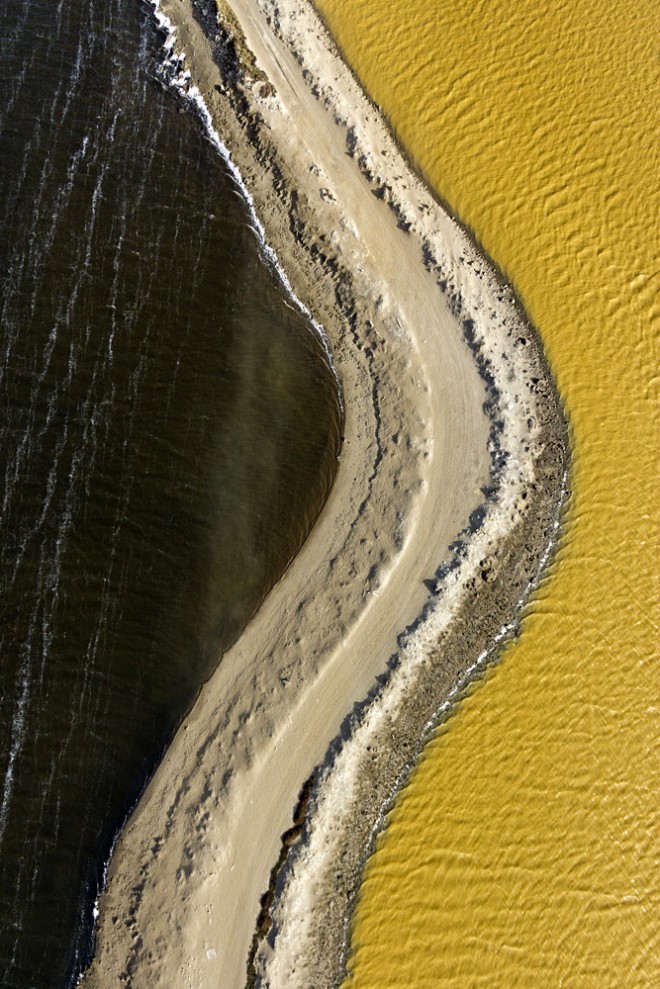
The southern end of the San Francisco Bay Area is known for expensive real estate, tech companies, and aerospace engineers. Less well known is its salt content.
Yet the salt industry has been a vital part of the South Bay for more than a century. Fly into any of the region’s airports and evidence of this appears as a vibrant quilt of briny pools in acid green, ochre, and shades of red that look toxic. These algae-infused intake and evaporation ponds, crisscrossed by channels and levees, are a surreal landscape seen best from the air.
Photographer Cris Benton has studied and documented this fascinating area for over 10 years, using cameras held aloft by large handmade kites. In his new book, Saltscapes: The Kite Aerial Photography of Cris Benton (Heyday Press), the retired architecture professor explains that kite aerial photography “fuels my fascination with photography’s capacity to reveal patterns and phenomena that lie beyond the capacities of our native senses.”
As it turns out, this method also reveals phenomena missed by satellites. “I can fill in that layer below Google Earth,” says Benton.
His kites, which fly up to 300 feet high, are closer to the ground than airplanes can safely fly. They inhabit airspace high enough to capture sublime panoramas yet low enough to reveal sharp details of the bay’s crystallization beds, brackish intersections, and ruins of past land use.
During Benton’s expeditions, his camera is suspended from the kite by a string at least 100 feet below, to facilitate stability. Once the camera is at an ideal altitude, he can aim it and activate the shutter through remote control.
“I compose by watching the camera rig, sometimes with binoculars though usually with the naked eye, and imagining what I will ‘see,’” he says.
He has experimented with a live video feed, but rejected it after a couple of tries. “I got bored just watching the screen,” he says. He finds the instinctive guesswork and imagined results more compelling. And shortcuts just aren’t in his nature–Benton also builds his own radio-controlled camera cradles, and sews his own kites on a vintage sewing machine he restored.
Benton has explored the South Bay with a deft eye and a historian’s ardent curiosity. His images may be as abstract as mid-century paintings, but they double as aerial archeology, revealing the borders of former evaporation pools, a defunct rail line, and the remains of cabins inhabited at the turn of the last century. The book presents a fascinating overview of the evolution of the local salt industry, including the origins of the conservation movement Save the Bay, and the encouraging collaboration between the Cargill salt plant and wetland restoration efforts.
This landscape has undergone, and is now experiencing, massive transitions. While salt production is still active, it has shrunk, and thousands of acres are slowly returning to marsh. Wildlife is reappearing, and the palette of the ground is shifting back toward a mottled vegetal green. Benton has documented the area in some quarter of a million images so far, and will continue to do so, revealing metamorphoses invisible to us on the ground.
Published in Wired
